Uniform State Waterways Marking System - Part 1
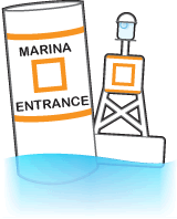
Information (Square)
Displays information such as locality, marina, GAS, campsite, and food.
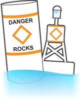
Hazard (Diamond)
Marks random hazards such as Shoals and rocks. Information concerning the hazard is illustrated within the orange diamond.
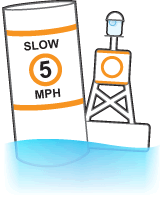
Control (Circle)
Indicates speed limits, wash restrictions, etc. Obey the restrictions illustrated within the orange circle.
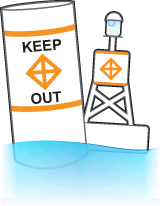
Keep-Out (Diamond with Crossing Lines)
Indicates areas where boats are prohibited, such as swimming areas, dams, and spillways.
27/33